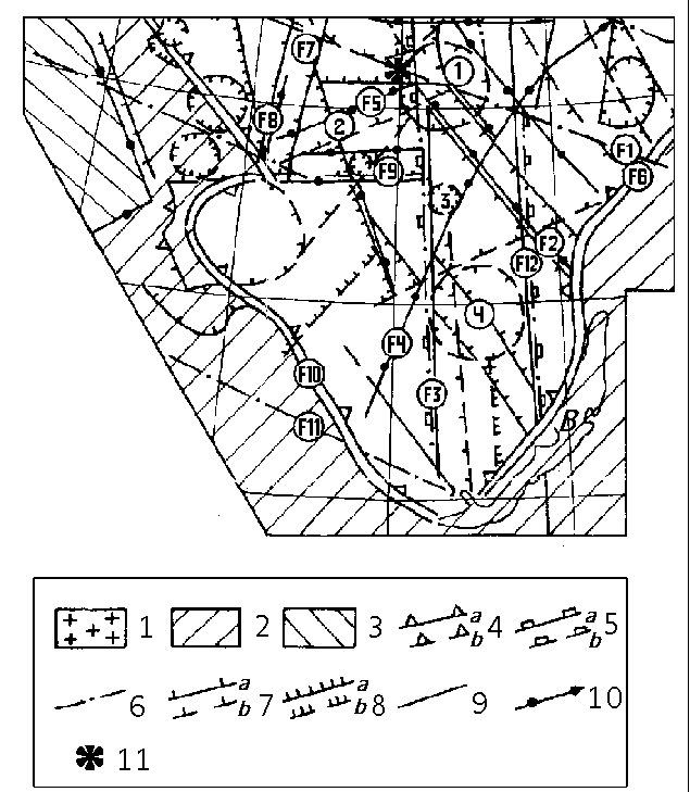
B - Lake Baikal; 1 - the Siberian platform basement outcrops; 2 - the plicated frame of the Siberian platform; 3 - the West Siberian plate; 4-10 - the tectonic faults from space data; 4 - the frame faults, seperating the Siberian platform (a - distinctly seen, b - less distinctly seen); 5 - the interplatform frame faults, seperating the plicated regions of the basement with different ages (a - distinctly seen, b - less distinctly seen); 6 - the transregional faults; 7 - the regional faults (a - distinctly seen, b - less distinctly seen); 8 - the other faults (a - distinctly seen, b - less distinctly seen); 9-10 - the tectonic faults from geophysical data; 9 - the frame faults; 10 - the regional faults; 11 - the epicentre of the Tunguska explosion;
THE LINEAMENT FAULTS:
F1 - the Beryozovsko-Vanavarskii fault;
F2 - the Norilsk-Markovskii fault;
F3 - the Angaro-Khetskii fault;
F4 - the Angaro-Viluiskii fault;
F5 - the Chadobedsko-Irkineevskii fault;
F6 - the Baikalskii fault;
F7 - the Chadobedsko-Tyichanskii fault;
F8 - the Irkineevsko-Nordvikskii fault;
F9 - the Nizshneangarskii fault;
F10 - the Prisayanskii fault;
F11 - the Sverdlovsko-Irkutskii fault;
F12 - the Baikalo-Taimyirskii fault;
THE CIRCLE STRUCTURES:
1 - the Vanavara circle structure;
2 - the Chadobedskaya circle structure;
3 - the Verkhnekatangskaya circle structure;
4 - the Angaro-Lenskaya circle structure;
